
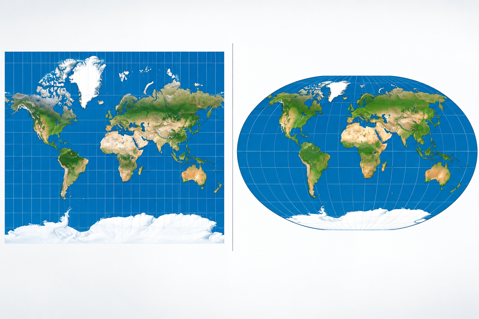
Quick answer: On September 4, 2026, the UN General Assembly voted 164–1 to adopt the “Correct the Map” resolution, which encourages governments, schools, and tech companies to use equal-area maps — like the Equal Earth projection — that show Africa at its true size. The resolution does not ban the Mercator map, and it is nonbinding. But it marks the first time the world formally agreed that the most familiar map on Earth misrepresents an entire continent.
Look at almost any classroom wall map, and you’ll see a version of the world where Greenland looms nearly as large as Africa. In reality, Africa is about 14 times bigger than Greenland. That gap between perception and geography is what the United Nations voted, almost unanimously, to fix.
For those of us looking at the world from Tunisia — the very northern tip of the African continent — this story is more than a cartography debate. It’s about how a continent of 1.4 billion people came to be visually shrunk for four and a half centuries, and what it takes to correct it.
What did the UN actually vote on?
The “Correct the Map” resolution was introduced by Togo on behalf of the African Group — the 54 African member states at the UN, Tunisia among them — with the backing of the African Union and the Bahamas. It passed on September 4, 2026, with 164 votes in favor, six abstentions, and a single vote against, cast by the United States.
The resolution encourages the use of map projections that preserve the relative areas of continents whenever comparative size is what a map is meant to show — in classrooms, media, government materials, and digital platforms. It specifically points to the Equal Earth projection as an accurate option, while recognizing the broader family of equal-area maps.
Just as important is what the resolution does not do:
- It does not ban the Mercator projection.
- It does not impose one mandatory world map on any country, school, or company.
- It does not change any border, territory, or sovereignty question. The measure applies only to the relative size of landmasses.
- It is nonbinding — a recommendation carrying moral and political weight, not legal force.
Togo’s Foreign Minister Robert Dussey put the case simply before the vote: maps shape education, imagination, and collective perception. “A fair map does not change the geography of the world,” he said. “It changes how we see the world.”
Why does the Mercator map make Africa look small?
The story begins in 1569, when the Flemish cartographer Gerardus Mercator designed a map for a very specific audience: sailors.
His projection had one brilliant property — a straight line drawn on it corresponds to a constant compass bearing. For navigation in the age of sail, that was invaluable. But the mathematics that make Mercator perfect for plotting a course come with a heavy cost: area distortion. The farther a landmass sits from the equator, the more the map inflates it.
Northern Europe, Canada, Russia, and Greenland balloon. Africa — which straddles the equator — stays close to its true proportions while everything around it swells. The result is an optical illusion the whole world grew up with:
- Africa’s real area: roughly 30 million square kilometers
- Greenland’s real area: about 2.16 million square kilometers
- The reality: Africa is approximately 14 times larger — yet on Mercator, the two can look comparable
To put Africa’s true scale in perspective: the United States, China, India, Japan, and much of Europe could fit inside the continent’s landmass simultaneously. From Cap Angela near Bizerte — the northernmost point of continental Africa, right here in Tunisia, marked by a monument shaped like the continent itself — to Cape Agulhas at Africa’s southern tip is a journey of roughly 8,000 kilometers.
An important nuance: Mercator doesn’t technically “shrink” Africa. It enlarges high-latitude regions far more than equatorial ones, which makes Africa look small by comparison. The distortion is relative — but the effect on perception is the same.
What is the Equal Earth projection?
Equal Earth is a much newer invention. Created in 2018 by cartographers Bojan Šavrič, Tom Patterson, and Bernhard Jenny, it belongs to the family of equal-area projections: if one region has 14 times the land area of another on the globe, it occupies 14 times the area on the map.
On Equal Earth, Africa appears as what it is — the world’s second-largest continent, dwarfing Greenland and rivaling the visual weight of Asia.
But no flat map is perfect, and Equal Earth doesn’t claim to be. Flattening a sphere onto a page always forces a compromise between area, shape, distance, and direction. Equal Earth preserves area at the cost of some shape distortion near the edges. Mercator preserves direction at the cost of area. Even the UN resolution acknowledges this, encouraging education about the limits of any flat map. The only truly honest representation of Earth remains the globe itself.
The real question was never “which map is correct?” It’s “which map is appropriate for what we’re trying to show?” And for teaching the comparative size of the world’s regions — which is how most people encounter world maps — an equal-area projection is simply the right tool.
Why does map distortion matter for Africa?
Because maps are never just maps. They hang in classrooms, open news broadcasts, and load by default on our phones. Over generations, the visual prominence a map gives — or denies — a region seeps into how people unconsciously rank the world’s places.
The resolution’s sponsors argue that Mercator’s distortions contributed to what they call the “symbolic minimization” of Africa: a continent persistently perceived as smaller, and by extension less significant, than it actually is. Advocacy groups behind the Correct the Map campaign, including Africa No Filter, frame the vote as a starting point — the goal is accurate maps in schools, textbooks, newsrooms, and on the digital platforms billions of people use daily.
There’s a fair-minded caveat the resolution itself makes: Mercator was not designed to diminish Africa. It was a 16th-century navigational tool that did its job superbly. The problem arose when a map built for sailing became the default image of the world for everything else.
Why did the United States vote against it?
The US was the lone “no” vote, with its representative dismissing the initiative as part of a “radical ideological project” and objecting in particular to the resolution’s references to reparations and “cognitive justice.”
The six abstentions — Estonia, Georgia, Lithuania, Moldova, Serbia, and Ukraine — mostly reflected a different concern. Ukraine said it supported correcting distortions affecting Africa but objected to how some Equal Earth-branded maps depict Ukrainian territory occupied by Russia. The European Union, which supported the resolution, stressed that it applies only to the relative size of landmasses and has no bearing on sovereignty or internationally recognized borders.
That distinction matters: a projection is a mathematical method for flattening the globe. Where borders are drawn on it is an entirely separate — and separately contested — question.
France, meanwhile, went the other way. On the day of the vote, Foreign Minister Jean-Noël Barrot announced that Paris planned to abandon Mercator for its own world maps — even though the switch makes France itself appear smaller. “Correcting a representation that distorts the world,” he said, “is already an act of truth.”
Will schools have to replace their maps?
No. No teacher is being ordered to pull the Mercator map off the classroom wall, and Mercator remains genuinely useful for what it was built to do — web maps still use Mercator variants at street level, where local shape accuracy matters and global area distortion doesn’t.
What the resolution encourages is arguably more valuable: teaching why different maps look different. A student who understands that Mercator answers a navigator’s question while Equal Earth answers a geographer’s question has learned something deeper than either map alone can show.
The defaults, though, have begun to shift. The African Union adopted Equal Earth for its own use before the UN vote, and with the resolution’s backing, governments, publishers, and tech companies have clear political cover to follow where size comparison matters.
The bottom line
The viral headline — “the UN abolished the old world map” — overshoots what happened. The UN banned nothing and mandated nothing.
What 164 nations did agree on is a principle that sounds almost too obvious to require a vote: when a map claims to show the relative sizes of the world’s continents, those sizes should actually be proportional.
Changing a projection doesn’t make Africa any bigger. It never needed to be bigger. From the beaches of Bizerte to the Cape of Good Hope, Africa has always been 30 million square kilometers. The map is only now catching up.
Curious to stand at the continent’s edge yourself? Cap Angela is an easy day trip from Tunis — our Bizerte guide covers how to get there, our photo tour of Tunisia’s historic places includes the cape, and there are plenty more superlatives in our facts about Tunisia.
FAQ
Did the UN ban the Mercator projection? No. The “Correct the Map” resolution adopted on September 4, 2026 explicitly does not ban Mercator or impose any single replacement. It encourages equal-area projections like Equal Earth when a map’s purpose is to show the relative size of continents. The resolution is nonbinding.
How much bigger is Africa than Greenland? Africa covers roughly 30 million km²; Greenland covers about 2.16 million km². Africa is approximately 14 times larger, even though the Mercator projection can make them look similar in size.
What is the Equal Earth projection? An equal-area world map projection created in 2018 by cartographers Bojan Šavrič, Tom Patterson, and Bernhard Jenny. It preserves the true relative areas of landmasses, so Africa appears at its actual scale.
Which countries voted against the UN map resolution? Only the United States voted against it. Six countries abstained: Estonia, Georgia, Lithuania, Moldova, Serbia, and Ukraine. 164 countries voted in favor.
Is the UN resolution legally binding? No. General Assembly resolutions of this kind are nonbinding recommendations. Governments, schools, and companies choose whether to adopt equal-area maps.
Where is the northernmost point of Africa? Cap Angela, near Bizerte in Tunisia — the true northern tip of the African continent, marked by a monument shaped like Africa, with Cape Agulhas roughly 8,000 km due south.
